| -> ARTWORKS |
Stadtplan Belgrad
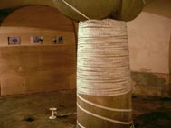
installation, 100m saum, 3 fotos
real presence, belgrad 2005
|
|
|
| click on image to enlarge |
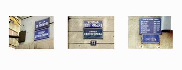
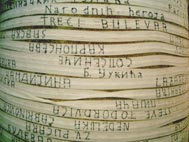
| In dieser Installation habe ich erneut das Thema des Stadtplans und die zusammenhängende Problematik der Repräsentation (s.h. „Stadtplan Wien“, 2002) aufgegriffen. Die tatsächliche Idee meiner Arbeit ist aus der Orientierungsschwierigkeit die ich zu Beginn meines Aufenthaltes in der Stadt empfand, entstanden. Viele Straßennamen stimmten nicht mit denen auf meinen Plan überein, und beide Schriftweisen, die Lateinische und die Kyrillische, kennzeichneten die Schilder der Stadt. Weiterhin merkte ich dass die Namen einiger Strassen mehr als fünf Mal im letzten Jahrhundert geändert wurden (die Schilder selber deuteten es). Ich war also auf direkter Weise mit der Repräsentationsgrenze von Stadtplänen konfrontiert, da diese Struktur keine Änderungen zulässt. Dementsprechend habe ich mich entschieden eine anderen Stadtplan aufzubauen, in dem das zeitliche Element des Wechsels im Vordergrund steht. Auf ein 100 m Saumband begann ich alle Straßennamen der Stadt aufzuzeichnen, abwechselnd ein Mal auf lateinisch und ein Mal auf kyrillisch. Da ich nicht einen Vordergrund und einen Hintergrund des Bandes definieren wollte, habe ich hin und wieder das Band umgedreht und auf der anderen Seite zu schreiben begonnen. Sowohl am Anfang wie auch am Ende blieb das Band ungeschrieben. Danach habe ich es auf eine Säule der Ausstellungsraumes aufgerollt, in einer Art unendlichen Spirale: die blanken Teile des Bandes deuteten einerseits auf die vergangenen Straßennamen, andererseits auf die zukünftigen. |
In this installation I pursued on some previous thoughts about city maps (see “Map of Vienna”, 2002) and the related problem of representation. The actual idea of the work arose from my own orientation difficulties during the first days I spent in Belgrade, as many street names didn’t correspond with those on my map, and both writing systems (Latin and Cyrillic) were used. Furthermore, I noticed that the names of some streets were changed more than five times in the last century (as it was documented on the street plates themselves). I was thus directly confronted with the limit of representation given by maps, as their constitution doesn’t allow to keep trace of the changes that affect also the present state of their represented system, the city itself. I thus decided to construct an “other” version of the city map, in which the temporal aspect of change is put in the foreground. Following two “real” maps, one in Latin, and one in Cyrillic, I began to write on a 100 meter long hem ribbon all the names of the streets alternating the Latin and the Cyrillic version. I somehow “linearized” the content of the maps: I started to collect and write down on the stripe all the names situated in the A1 rectangle of the maps; the names from the A2 area followed, and so on. Some blank ribbon space was left at the beginning and the end of the band. As I didn’t want the ribbon to have a front and a back side, I alternatively wrote on its both sides. Subsequently I rolled the band on a column of the exhibition space in a sort of endless spiral, where the blank leftovers at both ends of the band alluded to the previous street names, “forgotten” at the moment, and to the names that are still to come. |